Mappedin GIS Exporter
Mappedin GIS Exporter can be used to create building footprint datasets from a workspace. Enter API credentials, choose how multi-level maps should be handled, then generate and download ready-to-use files for Geographic Information System (GIS) and data integration all from a web browser.
Get an API Key
A Mappedin API key and secret are required to use the Mappedin GIS Exporter.
- To try the exporter with demo maps, use the keys on the Demo Keys & Maps page.
- To use your own maps, create your own unique key and secret. Using maps with your own key and secret requires a Pro subscription.
How To Use
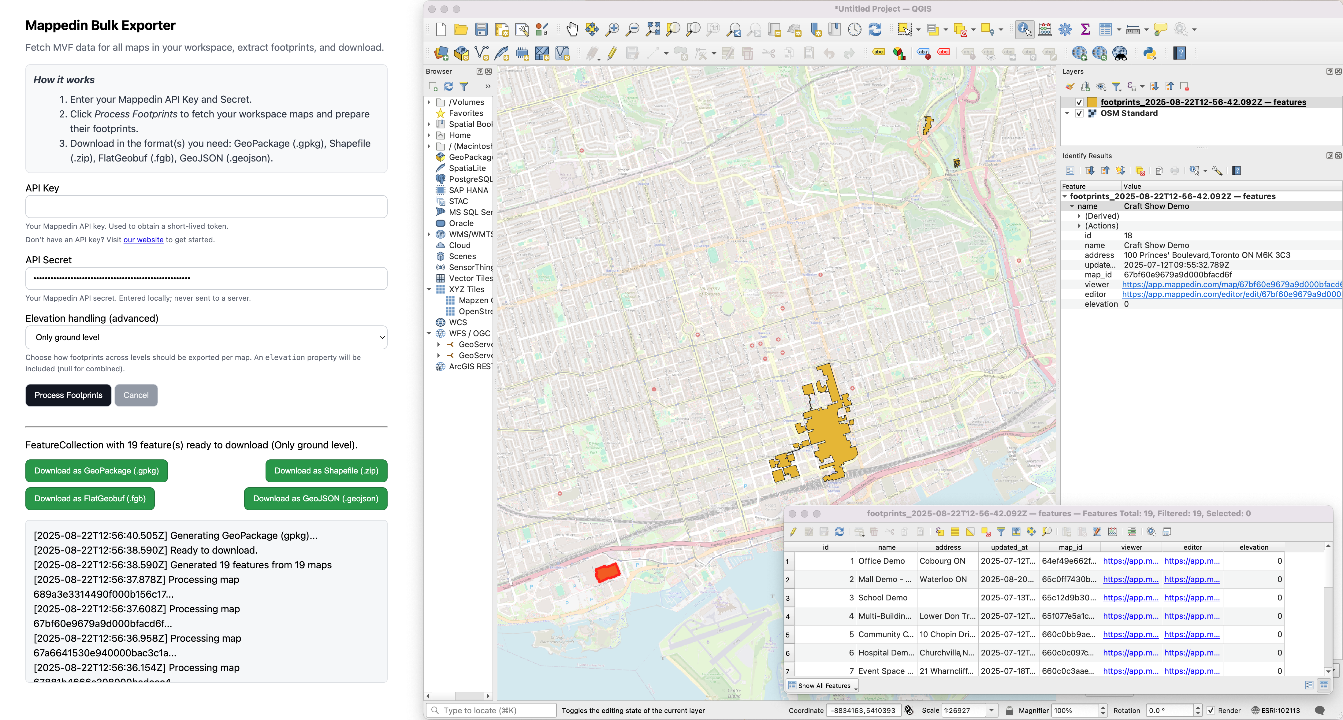
- Open Mappedin GIS Exporter.
- Enter an API Key and Secret.
- Choose Elevation handling for each map's floors:
- Only ground level
default: includes only floors with elevation === 0; exports one feature per qualifying floor withproperties.elevation = 0. - All levels combined
union: includes all floors (no filter); unions into a single MultiPolygon feature;properties.elevation = null. - Aerial levels combined
union: includes floors with elevation ≥ 0 (ground and aerial); unions into a single MultiPolygon feature;properties.elevation = null. - All levels separate: includes all floors; exports one MultiPolygon feature per floor with
properties.elevationset to that floor's elevation.
- Only ground level
- Click "Export Footprints". The exporter fetches all maps in the workspace, extracts footprints per selection, and prepares a FeatureCollection.
- When the status indicates it's ready, choose a download format:
- GeoPackage
.gpkg— recommended for best interoperability and fidelity - Shapefile
.zip - FlatGeobuf
.fgb - GeoJSON
.geojson
- GeoPackage
Mappedin GIS Exporter exports a single dataset containing one or more features per map, depending on the elevation mode. This dataset represents all maps accessible to your API key in the workspace.
Feature attributes
Each exported feature (MultiPolygon) includes the following properties:
namestring: Map name.addressstring: Map/site address, when available.updated_atstring: Last update timestamp for the map data.map_idstring: The map's identifier used in API requests.viewerstring: Viewer URL for the map.editorstring: Editor URL for the map.elevationnumber | null:0for ground-only features.- Floor elevation for "All levels separate".
nullfor combined modes ("All levels combined (union)" and "Aerial levels combined (union)").
Notes:
- All processing occurs in your browser
- API keys are sent only to Mappedin APIs and are not stored by this tool
- Processing time is dependant on the number and size of maps in the workspace
- Geometry is always exported as a MultiPolygon
- In Shapefile exports, long property names may be truncated to DBF field limits
- Maps with invalid geometry or missing data are logged and skipped; the export will continue for remaining maps
- Coordinate reference: WGS84 (EPSG:4326); no reprojection is performed